1095 days. Or 3 years. The numbers don’t matter; nobody’s counting. Each one is the same, each one misses you. Always my love.
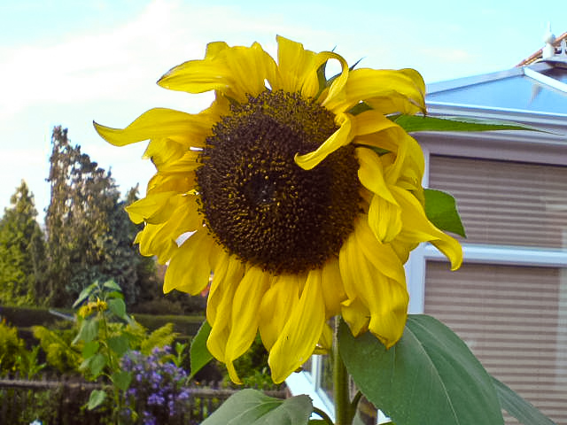
1095 days. Or 3 years. The numbers don’t matter; nobody’s counting. Each one is the same, each one misses you. Always my love.

Perusing events at The Royal Observatory, Greenwich came across this:
This summer we’ll be celebrating the arrival of the NASA spacecraft New Horizons at the dwarf planet Pluto in the asteroid belt.
Emphasis mine—Really? If that’s their level of astronomical knowledge these days I don’t think I’ll bother. Dear me.
Before this website existed I had another one, norcimo.com. For quite some time accessing a top level area of that site has redirected to a holding page. I’ve just changed things to redirect here instead. How exciting.
It seems the way to improve a disappointing park is to hold a local music festival in it—or so Heather and I discovered.
Continue reading

A view which shows the strength of Rochester Castle
Another trip to Rochester was long overdue and a sunny weekend offered the perfect opportunity. It seems we always manage to hit the weekend with engineering works on the trains though so we were left with the choice of a possibly unreliable rail replacement bus half way or, the route we took, the long way round via Bromley. Got there in the end though (passing through the new station they seem to be building) to glorious warm sunshine reflecting off the Medway.
Continue reading

A view of the infants from 1984
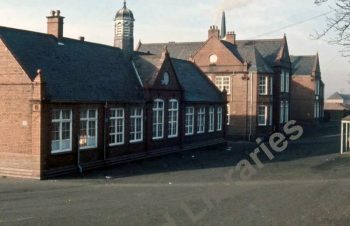
And now for a tale of a bit of a failure at finding something online. In general it’s a sign one is struggling when your own pages are turning up at the top. Anyway, basic premise and frustration: It seems impossible to find photos of my old school (I should point out that by old school I also mean the old buildings, from before they built the “new” buildings and knocked the old down to form the current playing fields).
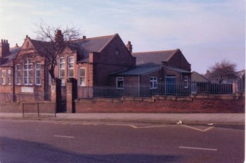
An undated view of the infants, seen from Whitehall Road
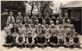
A Brighton Avenue school class outside the nursery in 1956.
There are a few of course. The easiest to find seems to be this shot from 1984, which I originally found on the new apparently defunct iSee Gateshead (if the date is correct then, given I was 7 in 1984, that’s probably my lollypop lady!) That also appears in the
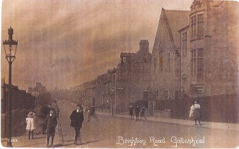
The junction with Whitehall Road
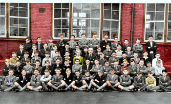
Outside Brighton Avenue school
iSee Gateshead also had this 1901 photo, which has a glimpse of the school on the left (the church on the right is still there, though the church hall is gone). I did also turn up this 1958 photo from from another source, with a little bit of very red looking exterior. But it was back to iSee Gateshead for the final and probably best photo, from 1966 (mislabelled Brighton Road School, see this blog post for some discussion of that). From memory that’s the junior school facing Brighton Road.

Seen in 1966
And that was about it! My quest for any more had failed. I don’t even seem to have any myself (a couple inside but nothing outside).
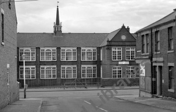
As seen from Balfour Street in 1989
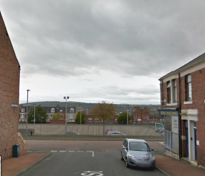
2004 street view down Balfour Street
Shortly before demolition (1989)
The Old Brighton Avenue
A couple more: Two more, looking along the rear of Ravensworth Terrace (now at Beamish) with the school in the distance:
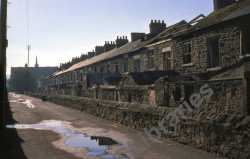
Rear of Ravensworth Terrace, with a distant Brighton Avenue school
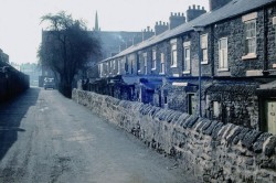
A view of the rear of Ravensworth Terrace, with Brighton Avenue school at the end
What I’d really like is a view form the other, Liddell Terrace, side. The search continues!
Where'd they come from?!:Bensham, late 1940s/early 1950s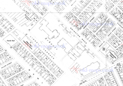
Pre-1953 Map
While looking for internal shots following the comments below I actually found I had these two shots in my collection—no idea where they came from or any more information about them
The first of these is another view from the corner of Brighton and Whitehall Roads, showing the three main school buildings. I distinctly remember that “shed” in the foreground. What was a surprise on seeing this were the low buildings behind that little wall. Certainly they were gone by my time; I can’t help wonder what they were. Looking through some old maps they appear to date from the late forties/early fifties (Which I think fits the photo).

Brighton Avenue school from the corner of Brighton Road and Whitehall Road
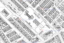
Bensham in the late 1960s/early 1970s
I think the maps show those buildings vanishing in the sixties/early seventies—I’m presuming this map with shaded buildings is showing the outline of where they were? Incidentally, it does show the lightwells I remember climbing down to retrieve footballs!. When I was at school there was a low wall, roughly where the wall in that photo is. It bordered what was known as the “clay field” which was basically the only bit of grass, slightly raised and running down to Liddell Terrace.
It looks like that wall is the same line as the fence visible in this (I believe earlier) photo, taken from that illusive other side (though really, I want to be further to the left). You can just about make out those lightwells on the larger building. The single storey building in my period held the canteen and, if memory is reliable, music teaching rooms. That same dodgy memory tells me that the top left room of the building behind was my first junior school classroom, with Mrs Knighton.

Finally another Gateshead Libraries photo, one of my favourites so far, as it shows a view across the playground (Brighton Road side) from the juniors across to the distant infants.
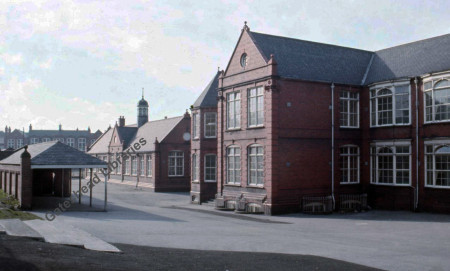
Looking across the full school

The school on the left in the snow, along with the now gone church on the right

Brighton Avenue infants in a blanket of snow. Probably late 1980s, early 1990s
After trawling through a couple of Facebook groups (realising you can search a group helps!) there are a few more. The first two make me feel cold, a reminder of the wintry walks to school and back of my youth. One is a view along Brighton Road from the corner with Whitehall, the school stretching away to the left. It’s unclear quite when the photo is from but it’s pretty much the view I remember. The other snowy scene is from roughly the same place, looking down the hill of Whitehall Road with the infants building huddled in the snow (and look how hard it is to distinguish road from path!)
The final shot looks back up the hill from the other end, and a much earlier time. I’d forgotten how substantial that building actually was, becoming taller as it stretched down the hill like that.

Looking up the hill at the infants. I’d forgotten how bulky it was at this end
This is the yard behind the “catering” block, with the junior school beyond

Looking across from somewhere down Bensham Road. Seen in 1983
Three further photographs. The first is basically the reverse view of the 1966 shot above (and presumably taken at the same time), looking back towards the Brighton Road side of the juniors.
Secondly we have an interesting, if obscured, view from somewhere down Bensham Road (near the corner with Liddell Terrace by the looks of it). The south of Brighton Road has gone, with Ravensworth Terrace removed to Beamish. I remember being sad when they removed those trees to build the new school. I don’t remember the school being so set back from the road at the south as it appears here, with the grassy area, but it was a while ago—the shot is apparently from 1983 so there’s not quite the chance I was in the building’s visible.
The final shot is something of a holy grail. This is my playground. The Liddell Terrace side of the school, from on the “clay field”. The later low extensions to the nearer building are all there and the junior school stands proud beyond (off left, a little out of shot, are the sheds). Though there’s smoke coming out the chimney the boarded up lightwells (or were they always? I don’t think so) and what looks like the new school in the distance suggest this might be near the end. Still nice to see it!

A view from the front, from on the “clay field” looking across the yard I remember playing in
A lovely shot from the corner of Liddell Terrace, showing the side of the school that my memory associates with (despite home being the other way)

Brighton Avenue from the corner of Whitehall Road nad Liddell Terrace
Noodling around the internet revealed something not actually photographic but none the less interesting. The planning application for forming the playground on the site of the old school (sadly there doesn’t seem to be anything from the old school itself, or its demolition) includes an existing elevation drawing, showing some of the details of the basic walls which surrounded, originally, the school itself.

The surrounding wall, as it was post building demolitions but before creation of the playground

Scanned section of the old OS map, with Brighton Avenue (now road) and the school highlighted
So why Brighton Avenue School was Brighton Avenue, rather than say Brighton Road, was one of those little personal mysteries we all have scattered in out lives. Things we’d sort of like to know, and occasionally remember to ask about, but never get round to properly researching when Google fails to shed instant light. Except it’s not a mystery any more (as you may have guessed from there being a blog post about it). One of my obsessions (on a level to neatly match little personal mysteries) is with maps, modern and old. Hence I bought a handful of old map reprints for my enjoyment (may I recommend the service of Alan Godfrey Maps while I’m at it). One of those was the 1894 OS map of south Gateshead (actually, the second edition of 1897). I can only presume I’ve never seen this before because right there is clearly marked Brighton Avenue (the highlighting in that scanned section is obviously mine). Today it would be, and is, called Brighton Road and indeed runs by the school. Everybody seems to have forgotten that it was originally Avenue. I have no idea when that changed, though I do have a 1930-something map with Brighton Road marked, so it must have been in those 40 years or so. Of course this had always been a strong candidate for an explanation, and wasn’t that uncommon (the Rawling Street shown a little further south on that section is now also a road for example) but it’s nice to finally know.
Here we go again then. Haway the lads.
Following on from last year’s adventure, Petts Woodstock swung back around, with the weather being kind again as Heather and I set off for some bands.
Continue reading